Three towns, one city
Alta Loma, Etiwanda and Cucamonga voted to merge in 1977. The seams still show — in the best way.
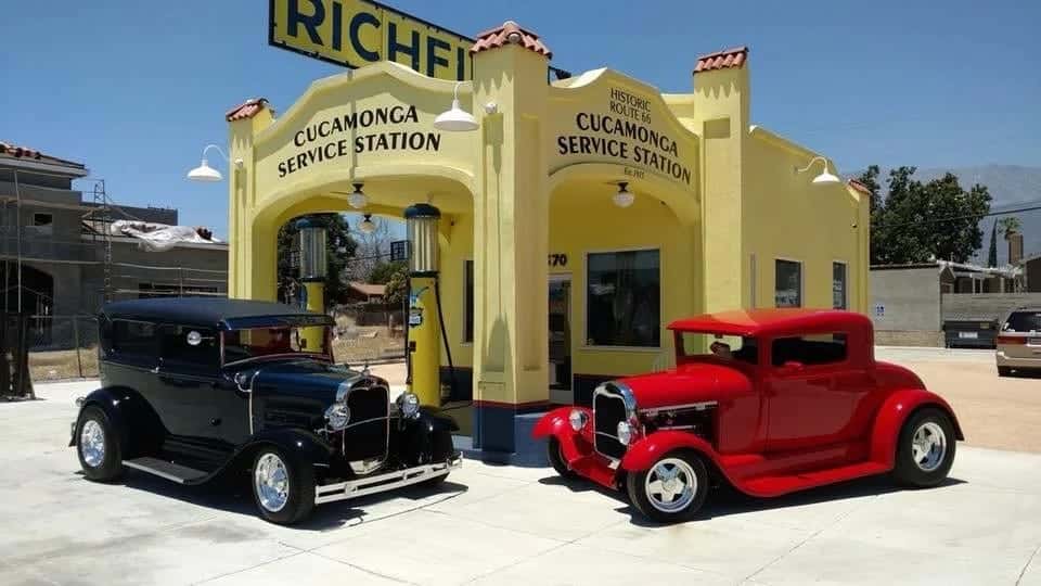
Rancho Cucamonga didn’t exist until 1977, when Alta Loma, Cucamonga, and Etiwanda voted to merge. The seams still show, in the best way: Alta Loma keeps horse trails and hillside streets, Etiwanda keeps its Victorian-era homesteads, and the old Cucamonga core along Foothill keeps Route 66’s roadside bones. The newer master-planned districts — Victoria, Terra Vista, Day Creek — filled in the middle with the city’s retail gravity.
These guides tell you how each area actually feels, what anchors it, and what’s worth crossing town for.
 © Foothill & Vine
Alta Loma
Alta Loma is the hillside third of the 1977 merger, climbing from Base Line toward the San Gabriel foothills. It kept what the valley below paved over: horse trails along the streets, eucalyptus windrows planted a century ago against the Santa Anas, and lots big enough that people still keep animals on them.
 © Foothill & Vine
Central RC
Central Rancho Cucamonga is the broad middle — the corridors along Haven, Archibald, and Base Line that hold city hall, Central Park, the Epicenter, and the everyday errands of a city of 178,000. It's the part of town with the least branding and the most daily life.
 © Foothill & Vine
Day Creek
Day Creek is the city's young northeast corner, named for the creek channel that drains the mountains above it. Built out mostly in the 2000s alongside the Victoria Gardens project, it's where Rancho Cucamonga looks newest — wide boulevards, big schools, and mountain views that explain the price per square foot.
 © Foothill & Vine
Etiwanda
Etiwanda was a Victorian-era colony town before it was a neighborhood — George Chaffey laid it out in the 1880s with some of the first electric streetlights in the West — and it joined the 1977 merger as the city's eastern third. The old settlement's bones survive: the Chaffey-Garcia House, stone curbs, and street names that remember homesteads.
 © Foothill & Vine
HART District
The HART District — Haven Avenue & Rancho Technology — is the city's name for its southern employment core, the grid of offices, logistics, and light industry between Foothill and the 10. It sounds like a zoning document, and mostly is, but it's also where some of the city's most interesting food and drink hides.
 © Foothill & Vine
Old Town / Route 66
This is the stretch of Foothill Boulevard where Cucamonga — the town, before the merger — actually happened, and where Route 66 still shows its hand. Between Vineyard and Haven you pass the 1915 service station, the Thomas Winery site with vines-planted-1839 credentials, and storefronts that served the road when the road was everything.
 © Foothill & Vine
Red Hill
Red Hill is where Rancho Cucamonga is oldest. The hill itself held a Kukamongan village by around 1200 AD — the 'sandy place' that gave the city its name — and the neighborhood grew up along the routes that followed: the stagecoach road, then Route 66, climbing the grade past the Sycamore Inn. Today it's the city's southwest shoulder, a mix of older housing stock, mature trees, and the densest run of genuinely historic sites in town.
 © Foothill & Vine
Terra Vista
Terra Vista is the planned community that filled the city's midsection through the 1980s and '90s — a Lewis Homes project of greenbelts, parks, and shopping centers strung along Foothill and Haven. It's less a destination than the connective tissue most residents live inside.
 © Foothill & Vine
Victoria
Victoria is the city's retail and civic center of gravity — the master-planned district around Victoria Gardens, the open-air center that has functioned as Rancho Cucamonga's downtown since 2004. If someone says 'meet me in RC' without specifics, they mean here.